
When we make maps we imagine a floor plan, a plot plan, a city plan, or even a global plan. Our point of view is directly overhead. If we tip our point of view a few degrees we get a combined side/overhead view. Before we could do this with Google satellite maps we did it first with measured imagination, then with cartographic projection using linear perspective and, later with the aid of aerial photography. Artists bring their own inventive exaggerations to aerial mapping hoping to heighten the feeling of space, drama, or induce vertigo.
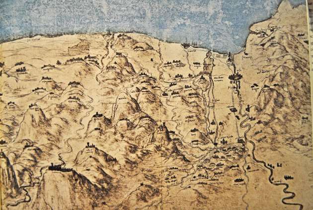
In 1450 Peselino invented an aerial map by as he illustrated Dante’s “Triumph of Fame, Time and Eternity” (example 1). His components such as ships are exaggerated in scale. Their presence helps signify the area of water. Leonardo will do the same fifty years later as a poetic cartographer. We see his mountains from an elevated viewpoint with iconic city markers situated on their tops. The city/castles are exaggerated in scale to improve legibility and to serve as icons labeling locations (example 2).
Example 1. Peselino’s World Map, 1450.

Example 2. Leonardo’s map.
Flying in small plane I circled Block Island. Sitting beside the pilot I enjoyed a broad panorama. I shot with a wide-angle lens to help with expand spatial distortion. After feeding my shots into Photo Elements I applied further distortions. Later, I redesigned the image in quick sketches. Finally, I found an older painting of a pond (example 3) whose colors could serve as an exciting substrate for my aerial image. I inverted this image. The light yellow area was now closer to the bottom instead of the top.
Example 3. Pond Painting to be inverted.

Next, I over-painted the inverted pond painting and blocked in my design (example 4). The left side of the image presents a foreshortened serpentine shape. The bottom of the image presents an advancing wedge shape because, I added a triangle of light to the lower right corner. Even at this earlier stage I used color recession. The colors and values at the front (bottom) are darker with more warmth. As the island’s colors ascend to the top they becomes paler and bluer.
In the next step, example 5 presents my initial perspective elastic, grid-work which moves from larger bright shapes to smaller ones as they recede. The roads also snake back into space weaving between the progressively smaller and thinner field-shapes. In example 6 you see the image with iconic house shapes, as well as the soft crenellated edges of dark tree lines. I further developed the transition from higher keyed color to muted pastels to amplify the feeling of a receding space. I overlaid atmospheric perspective over the linear perspective foundation.
Example 4. Step one, Laying in the Image.

Example 5. Applying the initial perspective grid.

Example 6. The image to date.

I conclude with three aerial (Eye in the Sky) paintings. Each is highly dependent upon the converging vectors of linear perspective, color recession, dissolving edges, and atmospheric perspective. Each image is 36×36, oil on anodized aluminum. All three examples demonstrate multiple layers semi-opaque glazes.
Example 7. West Side Stories, a Luminous Compilation.

Example 8. Eye on Manhattan.

Example 9. Misty Manhattan Silhouette.

I invite you to “CAMERAS,COMPUTERS, and PAINTING; PAST, PRESENT and FUTURE,” my upcoming Sunday evening lecture at the Silvermine Art Center in New Canaan, Ct on January 31st at 4:30 PM.
Betsy Duncan
I always love the way you push the limits! Beautiful work.
Margaret Hunt
I have been making maps too but nothing so fabulous as yours. Mine are more traditional maps of my travels.
Fredric Neuwirth
I have just finished a painting of clouds on the CT River and have glazed it with Charvin Eva Pink. It has taken on a whole new atmosphere Your Eye in the Sky reminds me of it. For your information the weather report from St Johnsbury, VT is called ” Eye in the Sky” from the Fairbanks Museum. More Snow this morning & it looks beautiful.
Shirley Ploog
I always love the information you provide David, as usual a very informative read.
Thanks for sharing your wisdom!
hilda hayson
my computer is glitchy..time for a new one. I don’t know if the prior email went. bought some of your dvds. Watching your video. You are scrubbing/removing paint w/ papertowel down to the bare canvas? looks like it is just barely tinted in the lightened areas. If there is no paint in that area does it look stained but not painted (no brush strokes no paint?) thank you.
Jody Hawkins
Thank you for this informative post David. I’ve been a cartographer for many years and I love when map making and art merge with such creativity!